 |
| No, not Sauvage. |
Savage.
 |
| Some guy climbs the 30% Westernport Wall on Big Savage Mountain in the Savageman Triathlon. Perhaps the only epic climb in the region we did not face last weekend. Credit enduranceracingmagazine.com. |
Here is a map of the route. As an out-and-back, riders traverse the route twice.
 |
| From the ride web page at http://dcrand.org/dcr/SR600/01/index.html. |
"I'm happy to report that the ACP approved my Big Savage Super Randonnee 600K, so it is now another option for those who would like to tackle one of these challenging rides. Super Randonnées are a new category of rides organized by Audax Club Parisien (ACP). They are mountainous permanents of 600 km (373 miles) with over 10,000 m (32,800 ft) of elevation gain."
Thus, the route imposes whatever challenges one encounters on a 600K, which I've blogged here before, added to whatever challenges one encounters climbing Mt. McKinley twice. Minus the glacier travel, I suppose. In exchange for the additional challenge, the kind folks at Audax Club Parisien grant an additional 10 hours over the normal 40-hour limit for a 600K.
I agreed to Damon's plan because he had made it and who was I to interfere: we would start from Hancock, Maryland, at 5 am on Saturday of Labor Day weekend; overnight at the ride's southern terminus in Woodstock; sleep well; and return 300K on Sunday. We eschewed any overt goals, although in the back of my mind I thought riding this in normal 600K time -- 40 hours -- might be a nice victory. I kept that one to myself, however.
Borrowed from the ride web page, the below elevation plot shows the major climbs and locations of the major towns.
 |
| Thanks to Bill for the helpful geographic names on the profile. (http://dcrand.org/dcr/SR600/01/index.html) |
Otherwise put, two things keep me going while riding in the mountains: (1) the promise of bragging rights if I finish this doggone ride and (2) the prospect of the other side of the mountain. This ride has both.
The start was wet and foggy and even chilly and the batteries on my DiNotte light were weak, leaving me with a lame glow from the ancient Opticube lighting my way. Thankfully the pavement was marvelous and cars were nonexistent for 35 miles to Cumberland. I've always wanted to ride the "National Highway" -- US 40 and, where the US highway coincides with the Interstate, its alternative routes -- and that weekend we did it for 60 miles each way. The huge upside is that the road runs halfway between two interstates, 70 and 68, along that stretch. Those highways take all the trucks and most of the cars, leaving US40 (and Highway 144 in stretches) to us cyclists.
 |
| Wrong season, but this is indeed about what it looks like. Including the lack of traffic. |
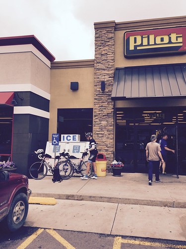 |
| Grantsville, MD. Controls were not all pretty, but -- I must say -- very serviceable. Very. |
We were rewarded on the second leg with a marvelous spin on perfect pavement on a false flat (downhill) along the side of Big Savage Mountain, before ascending the hill a second time.
Appalachian mountains form in long, unbroken ridges, rather than singular peaks like one sees in the west. From above the range looks like a set of waves piling up before breaking on the shore. So a mountain like Big Savage will be narrow east to west but many miles long north to south, and the northwest vertex of the route map at Grantsville comes on the west flank. By heading back toward the southeast, one must re-ascend the hill before descending into Westernport. So climb we did.
And then descend. But this one was not pretty: according to an old race report from the infamous Savageman Triathlon:
"Then the fun began. The next 3/4 (?) mile or so seemed to go straight up and it seems they just laid down a new chip-seal road so there was a lot of loose gravel that made getting out of the saddle next to impossible." (http://forum.slowtwitch.com/forum/Slowtwitch_Forums_C1/Triathlon_Forum_F1/SavageMan_Course_Review_-_HTFU!!!_P1966276/)
Well, on this day we were going down that part, and it had not changed since this report from 2008. I was in the mood to let things go and in return I once rolled right off the side of the road, necessary to avoid the alternative of a skidding fall.
Keyser WV was next. It hadn't been far from Grantsville, so we spent little time here -- and that was standing next to a CVS cramming down potato chips. Moorefield was 40 miles distant, more downhill than up. But what a 40 miles it nonetheless turned out to be. The coup de grace was a summiting of Patterson Creek Mountain, the summit of which is lower than nature intended due to mountaintop removal coal mining.
 |
| If ever there was proof of the failing of sacrificing long-term resources for short term gains, this is it. Teddy Roosevelt, wherefore art thou? |
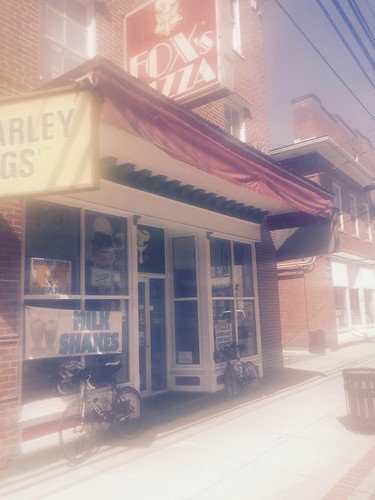
Down Patterson Creek and roll comfortably into Moorefield along the North Fork of the South Branch of the Potomac River. That last five miles is a lovely stretch of highway. And Moorefield is a cute town for West Virginia. Almost weekend-home kind of cute. The control was at Fox's Pizza, a West Virginia chain that is an institution -- despite the universally held, and accurate, view that Fox's may be the worst pizza available, including those you can get in the freezer at Walmart. I have replenished after more than one paddling or climbing adventure in a Fox's in one WV town or another.
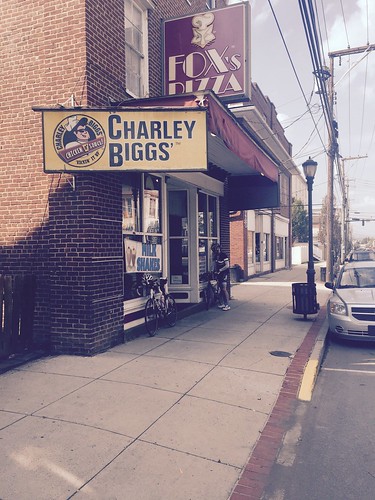 | |
| Fox's Pizza in Moorefield. |
South Branch Mountain: I had hoped Patterson Creek Mountain was the real bear and we had misunderstood its location relative to the Moorefield control. Damon corrected my misimpression. He was right.
South Branch Mountain lies between Moorefield and the magical Lost River Valley. It is a 2000 foot climb that takes about 4 miles. 500 feet per mile -- that's a 10% grade. Tough, even painful, but possible. Right?
Turns out the first two miles were easy. That left maybe 1500 feet for the remaining two miles. How do you like them apples?
We climbed. We shared gallows humor about what was coming. I once naively said "this isn't that bad. Maybe Bill was just tired." I then found myself alone and metaphorically descending into a dark pit. When I rounded a switchback at my rope's end and saw the next switchback was worse, I walked. Not far -- maybe 100 yards -- but enough to round that next, horrific pitch, and remount for the final and thankfully more gradual push to the summit.
South Branch Mountain may be the single hardest climb I have done in my cycling career. It is the hardest on the east coast by a mile, and if a western climb beats it -- perhaps Grand Mesa in Colorado -- it is through sheer size and elevation. But for all that, the climb up South Branch Mountain through Lost River State Park is a lovely road. Just marvelous. I suffered dearly and yet I want to go back, and soon.
And the backside lets you into the magical Lost River Valley, a little-known gem far from the nearest highway and abutting the George Washington National Forest. Twilight found us as we spun over rolling hills for 20 miles or so into the Lost River Grill. The grill is my all-time favorite cycling rest stop.
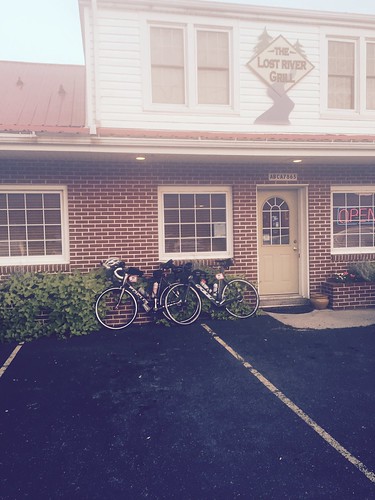 |
| The grill. Friendly, affordable, cozy, and incomparably located. Go here. |
 |
| The forest follows the VA-WV border for much of its north-south stretch. |
I was tempted not to set the alarm, but we did. And in a rare experience on a multi-day ride, I slept like a baby from 11:30 pm until 6 am. We were on the road at 7 am sharp, back over Wolf Gap an hour later. The second time through the GW Forest, with a little more energy in the legs, we could fully appreciate the perfection of new tarmac, false-flat downhill, and dry mid-60-degree air. Valhalla for Randonneurs must be a fall morning riding west from Wolf Gap in the GW Forest.
 |
| Wrong season, right road. Ignore the arrow. From Hikingupward.com. Unlike in this picture, the pavement is brand new this summer. |
The climb from the southeast was uneventful. The run along the ridge of the mountain was a treat including, among other things, a hearty wave from a retired couple enjoying the morning on their porch with a view over the valley. And the descent, well, I felt like I was on skis.
We started fast, dropping over the rounded shoulder of the ridge. Somewhere I passed Damon before entering impossibly steep switch-backs that had me out of the saddle for control and feathering the brakes to keep them cool. A black bear tumbled across the road not 20 yards on front of me. Had it been closer we would have tumbled together, as I was not stopping that short without taking flight. There were no cars. Thankfully Bill had provided warning of the gravelly switch-back to the right, the same one I walked in a moment of utter despair the prior afternoon. Good curvy descents have you shifting weight fore and rear, keeping it where the bike bites into the turn, like riding the edge of a giant-slalom ski as it bites into corduroy on a steep groomed trail. Shades of a long Copper Mountain cruiser run I remember from 27 years ago.
As the grade relaxed, the road straightened out, until I was on a gently waving series of long-radius banked s-turns on the lower stretches of the mountain. I was afraid of deer, but I was not willing to use the brakes. For two miles in maybe 3 minutes I just plotted my move if a careless odocoileus virginianus saw fit to cross my path at an inopportune time. One did not.
Damon and I rejoined when the mountain road ended and we cruised into Moorefield with two-thirds of the ride in the bag.
 |
| Fox's, take two. Too tired to worry about a little fog in the lens. |
The hardest stretch was from Moorefield to Keyser and Keyser to Grantsville. The pavement quality deteriorated; two hills to climb included 20%-plus grades; the sun was shining brightly; and we had 1500' fewer feet to descend than the maybe 7500' we had to climb. Climbing became lowest-gear standing jerks; I spent more time in single-digit miles-per-hour than I care to confess. The highlight was a massive bacon-cheeseburger at the Stray Cat Wing Shack in Keyser, supplemented with fries, chips-and-salsa, a salad, and well over a gallon of coca cola.
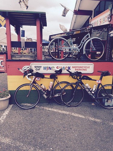 |
| The Stray Cat Wing Shack in Keyser. As much of a biker hangout as it looks. Most bikes there do not look like ours. |
In contrast, I found myself forgetting the "pull up on the left leg" mantra that helps me keep the power up on a normal ride. I had precisely the strength to get the legs to the top of the pedal stroke and to let gravity carry them back to the bottom. Thankfully my Garmin head-unit got lost on the drive home. It is nearly certain that my finishing power output in watts dropped out of the triple-digits.
The road was as marvelous going east as it had been going west. Once again the busy Interstate running parallel pulled off all but the rare car. But for one troglodyte just west of Cumberland who aimed a full big-gulp at Damon out of the window of a Jeep Wrangler, we had no unpleasantness with cars. And when we got out of the towns the sky opened back up with intense views of the stars above.
Like all rides of any length the last [X] miles are sheer torture. X is a variable figure, but it is something like 10*y with y being the number of 200Ks being attempted. In this case, we were happy at the Sheetz in Cumberland, 35 miles from the end. Climbing Town Hill 10 miles later was not fun, but it was not terrible. My recollections from there on -- with 25 miles to go -- are increasingly bleak. I do know that bushes started to charge at me and insects crossing the road grew to inches in length. I also know that descending became torture and the prospect of ascending brought tears to my eyes. Sideling Hill, the last substantial climb, was at an 8% grade as torturous as the 15% average grade on the hard part of South Branch Mountain.
But like all rides the end eventually came. Here is the bike in Hancock.
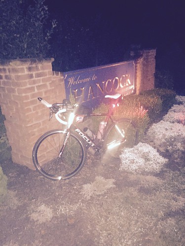 |
| At the end. |
There's enough text above that a summary is hardly needed. This ride was long, this ride was hard, this ride was beautiful. Most of all this ride was an accomplishment. I'm glad we did it. I'd even consider doing it again. On the other hand, there are lots of other windmills to chase and dragons to slay.
8 comments:
Nice write-up. I took a look at the ride profile above and thought, "wow that's a lot of up and down in only 600KM". Then I realized that was all just the first 300K.
On the other hand, it sounds like you had a plan, and stuck to it remarkably well. An enviable accomplishment. Also, impressive that you survived the bacon cheese burger and nachos at the stray cat. I imagine many a rider would have quit the ride after that meal.
Agreed, a quality write-up, and one rather less bitter than mine. There's no question you were better prepared for this than I was, and it showed. I think you're well placed to not race Natchez in 3 weeks. Consider that caffeine taper we discussed...
I will say that, stepping back a bit for perspective, this ride went about as well as it could have. No mechanicals, and I was off my bike and entirely untrained until late June. At that point, 40-mile rides were difficult. Two months later, and with wedding planning to boot, we made it through this -- I shouldn't be complaining. But I will say with all sincerity that, had I been riding solo, this would have been a DNF.
I'm not able to post comments on your blog for some reason, so I'll post my comment here. Remarkable effort, and a great result. Regarding your last comment though, I do have a thought.
You, and perhaps to a lesser extent the other contributors to this blog, are fortunate to be able to dispatch a 1200 with relatively little drama. Tough 400K? OK, it might take 17 hours instead of 15. But the interesting thing to remember is that for many in the rando community, the rides that might seem to some like checklist items are epic ordeals. I've seen people finish a 1200K minutes before the final control closes, able to count the hours of sleep over the last 4 days on one hand. Sometimes without even needing their thumb. Which is good because their entire body has enough nerve damage that they can't feel their thumbs anyway.
The stronger randos generally don't need to think about the distance so much as trying to beat their PRs at that distance. Maybe take one real control stop (i.e. get off the bike) every 200K. I think that the SR600 is a brilliant way to introduce the 'physical challenge' aspect of randonneuring to that group. What I find interesting about yours and Max' writeups is that you actually did the things that the tail end of the rando bell-curve do on a typical brevet.. You stopped at the controls, filled your faces with food, and tried to recover enough for the next segment.
So to that I say "huzzah". Proof that brevets needn't be just a longer club ride. They can be an epic adventure, and to me it sounds like yours was.
Interesting point. One could approach this as an all-out effort, but of course that requires specific training. You are furthered hampered by rules against drop bags and outside support, even at controls, so you are really touring this thing. I do think it would be an intriguing goal to ride the nation's SR600s in 40 hours each. I'm not sure how realistic it is to consider the flat out efforts that Petervary might be able to bring to them.
Preparedness: I had the weird and sui generis experience of showing up at the start with no nerves and never really questioning my ability to finish the ride. It really was weird. And it is purely a question of lots of miles since late June.
Great report, Max! And for all of the difficulties that you and Damon described, you hold the course record -- for now. Bill
I built a bike for a friend with super hill friendly gearing, a compact in front, XT 11-36 in back. God forbid I ever attempted one of these rides, but theoretically, not caring if the shifting was a bit less precise or minding the gaps, would that sort of gearing potentially save my arse from a DNF? I think as long as I can spin the steep stuff, though slow, it'd be much better for my psyche and I would keep going and don't know if there's a huge drawback to that methodology.
34-36 granny should definitely do it. I think I'd go back with a 34-28, as low as I can go with a short RD, but I now have a 34-32 on the Salsa and would find that a much happier ride.
Part of my challenge was that I carried more weight than I needed. Had a full camelback on more than one of the worst climbs.
Post a Comment